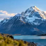
Few tracks in New Zealand pack as much altitude, as many staircases, and as much raw alpine scenery into one day as the Mueller Hut Route. Sitting inside Aoraki / Mount Cook National Park, this route climbs from the valley floor straight into glacier country, finishing on a rocky ridge with Aoraki / Mount Cook, Mount Sefton, and the Mueller Glacier laid out in front of you. It is short on paper and brutal in practice, and that combination is exactly why it has become one of the most talked-about day hikes in the Mackenzie region.
This guide pulls together the practical detail you actually need before you lace up your boots: accurate distances and times, what the track surface is really like stage by stage, when to go, what it costs to stay in the hut, what to pack, and the safety information the Department of Conservation wants every visitor to read first. There is also a full FAQ section, a track ratings table, an elevation profile, and a few honest opinions from someone who has walked plenty of Mackenzie tracks and knows this one is not like the others.
Quick Facts: Mueller Hut Route at a Glance
| Detail | Information |
| Location | Aoraki / Mount Cook National Park, Canterbury region, South Island |
| Trailhead | White Horse Hill car park, end of Hooker Valley Road |
| Total distance | Approximately 10.4 km return (5.2 km one way) |
| Elevation gain | Around 1,000 to 1,050 metres one way |
| Highest point | Mueller Hut, approximately 1,800 metres above sea level |
| Time (up) | 4 to 5 hours to the hut |
| Time (down) | 3 to 4 hours back to the car park |
| Official DOC grade | Advanced / alpine route |
| Track type | Formed staircase to Sealy Tarns, then unmarked alpine route with pole markers |
| Car parking fee | NZD 2.50 per half hour, capped at NZD 25 per day |
| Hut fee (overnight) | Paid per adult, booking required in advance through DOC |
| Dogs | Not permitted anywhere in the national park |
Where the Mueller Hut Route Starts and How to Get There
The route begins at the White Horse Hill car park, right at the end of Hooker Valley Road inside Aoraki / Mount Cook National Park. If you are driving from Twizel or Tekapo, you will follow State Highway 8 to State Highway 80 and continue to the very end of the road, past Mount Cook Village. Anyone road-tripping through the region tends to base themselves in Twizel for a night or two before tackling the Mackenzie’s big hikes, and our full Twizel travel guide covers where to stay, eat, and stock up before you head into the park.
Before you set off, it is worth calling into the Aoraki / Mount Cook National Park Visitor Centre at 1 Larch Grove, Aoraki / Mount Cook Village, 7999. The centre is open daily, generally from 8.30am to 5pm in the summer season and slightly shorter hours in winter. Staff run the intentions system that trampers should sign into before starting an alpine route, and they hold the most current weather and track condition updates for the day. Phone: +64 3 435 1186.
There is no public transport directly to the trailhead, so a private vehicle, rental car, or organised shuttle from Twizel or Tekapo is the only realistic option. Fuel up before you arrive, since Mount Cook Village has only limited fuel and grocery options.
Track Breakdown: What the Route Actually Looks Like
Stage One: White Horse Hill to Sealy Tarns
The first stage follows the Kea Point Track before splitting off onto the Sealy Tarns Track. This section is fully formed, with a long run of timber and stone steps zig-zagging up the mountainside. Most people count somewhere around two thousand steps by the time they reach the tarns, and this is the part of the day that tests your legs and lungs the most, even though technically it is the easier half. Expect it to take roughly two hours at a steady pace.
Sealy Tarns itself is a natural rest stop and a turnaround point for hikers who only want the Sealy Tarns experience rather than the full alpine route. Two small glacial tarns sit on a ledge with a postcard view back down the valley and across to Mount Sefton. It is also the last realistic point to reconsider continuing if the weather is closing in, since there is no shelter and no alternative route beyond this point.
Stage Two: Sealy Tarns to Mueller Hut
Past the tarns, the maintained track ends and the alpine route to Mueller Hut begins. This section is marked only by orange poles spaced roughly every 200 metres, winding through tussock and herb field before crossing a rocky basin. From there, the route climbs a loose scree slope for around 50 vertical metres to reach the ridgeline, which is the steepest and most physically demanding section of the entire hike.
Once on the ridge, the view opens up dramatically across the Mueller Glacier and the ice-draped face of Mount Sefton. From here it is roughly a twenty minute walk south along the ridge, following the marker poles through a rocky basin, until Mueller Hut comes into view. This upper section is not a formed track, and DOC is explicit that it should only be attempted by people with sound alpine judgement and appropriate gear, particularly outside the summer months.
If you want a shorter, gentler alternative in the same general region that still delivers a big payoff for less effort, the Mt John Summit Circuit Track in Tekapo is a good option to pair with your Mackenzie trip, with sweeping views over Lake Tekapo instead of glacier country.
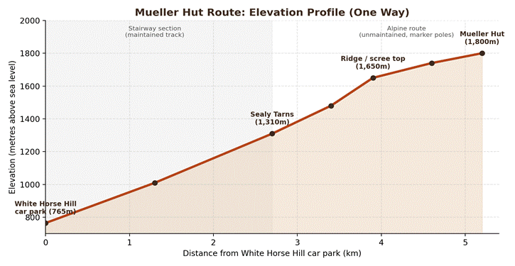
Mueller Hut Route Elevation Profile
The chart below shows how sharply the track climbs across its 5.2 kilometre length. There is very little flat ground anywhere on this route, which is a large part of why it feels harder than its short distance suggests.
Best Time of Year to Hike Mueller Hut Route
Mueller Hut sits in a genuine alpine environment, and conditions change quickly at this elevation. The Department of Conservation splits the route into three practical windows:
- Summer (December to February): the most accessible season, suited to hikers with moderate tramping experience who check the forecast and turn back in poor visibility or high wind.
- Winter (June to August): requires proper mountaineering skills, including travel on snow and ice with an ice axe and crampons, plus avalanche transceiver, probe, and shovel use.
- Spring and autumn (September to November, March to May): winter-like conditions can appear with little warning, so check with the visitor centre before you commit.
Avalanche danger on this route is considered significant from April through to mid-November, though slides can technically happen at any time of year. Anyone heading up outside the peak summer window should check the New Zealand Avalanche Advisory before leaving the car park, regardless of how settled the weather looks from the valley floor.
Difficulty: Is Mueller Hut Route Right for You?
DOC officially grades the Mueller Hut Route as an advanced alpine route, not a standard day walk. That grading matters. The distance is short by New Zealand tramping standards, but the elevation gain is packed into just over five kilometres, and the upper half has no track surface to speak of. A reasonable level of fitness, sure footing on loose rock, and a realistic assessment of the weather forecast all matter more here than they would on a typical formed track.
If you are newer to alpine terrain, consider walking as far as Sealy Tarns first as a standalone outing. It delivers a genuinely excellent view for roughly half the effort, and it lets you gauge your pace and the weather before deciding whether the second half is a sensible idea that day.
Staying Overnight: Mueller Hut Bookings
Mueller Hut has 28 bunks, a communal cooking and dining area, and non-flush toilets. Because of its popularity and limited capacity, bookings are compulsory during the main summer season and are made online through the Department of Conservation’s hut booking system well in advance, particularly for weekends and settled weather windows. There is no food, fuel, or gas available at the hut, so everything you plan to eat and cook with needs to come up the mountain with you.
Staying overnight also means you get to watch the light change over Aoraki / Mount Cook at dusk and dawn, which is arguably the single best reason to consider the extra weight in your pack rather than rushing the round trip in a single day.
What to Pack for Mueller Hut Route
| Category | What to bring |
| Footwear | Broken-in tramping boots with ankle support, ideal for scree and uneven rock |
| Layers | Wool or synthetic base layer, insulating mid-layer, waterproof and windproof shell |
| Head and hands | Warm hat, sun hat, gloves, sunglasses |
| Water | At least 2 litres per person; tarns water is generally fine but treat if unsure |
| Food | High energy snacks and a proper lunch; no food is sold on the route |
| Navigation | Map, and a charged phone; note that the alpine route above Sealy Tarns is unmarked track, not a formed path |
| Safety extras | First aid kit, headtorch, emergency shelter, and a distress beacon for overnight or off-season trips |
| Winter additions | Ice axe, crampons, avalanche transceiver, probe, and shovel |
Track Ratings and Reputation
Community hiking platforms consistently rank Mueller Hut Route among the very best alpine day hikes in the country, and it regularly places among the top trails nationally on trail-review sites. It is worth noting that ratings on outdoor platforms reflect the views and physical challenge, not how easy the track is, so a high score here is really a comment on the scenery-to-effort ratio rather than a suggestion this is a casual walk.
| Source | Rating | Notes |
| Hiking Project trail database | 4.8 out of 5 | Ranked in the top few trails in New Zealand by community vote |
| White Horse Hill campground reviews | 4.5 out of 5 | Reviewers praise the alpine views and trailhead access; note basic facilities |
| Aoraki / Mount Cook Visitor Centre | Consistently high visitor feedback | Frequently described as one of the best DOC visitor centres in the country |
Nearby Things to Do After the Hike
Sore legs the next day are almost guaranteed, so plan something gentler afterward. Queenstown is roughly a two and a half hour drive south and makes a good base if you are continuing your South Island trip; our guide to the best cafes in Queenstown is a handy list for the morning after a big hike. If your visit lines up with late spring, it is also worth timing your trip around the Mackenzie’s wildflower season; our guide to lupin season in New Zealand explains exactly when and where the roadside colour peaks along State Highway 8.
Final Thoughts
Mueller Hut Route rewards anyone willing to put in a genuinely tough climb with one of the most complete alpine panoramas available on a single day hike anywhere in New Zealand. It is not a track to underestimate, and the jump in difficulty above Sealy Tarns catches out hikers who assume the short distance means an easy outing. Respect the DOC grading, check the forecast honestly rather than hopefully, and turn back if conditions sour. Get the timing and preparation right, and the walk up to that little red hut below Mount Ollivier is very hard to beat.
Frequently Asked Questions
How long does the Mueller Hut Route take?
Most parties take between six and eight hours for the full return trip, with four to five hours climbing to the hut and three to four hours coming back down. Fitness, weather, and how often you stop for photos all affect the total time.
Can I do Mueller Hut Route as a day hike?
Yes. Many hikers complete it in a single day without staying overnight at the hut. You do not need to book or pay hut fees if you are not staying the night, though car parking fees still apply at White Horse Hill.
Do I need to book to hike Mueller Hut Route?
No booking is needed for a day walk. If you plan to stay overnight in Mueller Hut, booking in advance through the Department of Conservation’s online system is required, particularly during the busy summer months.
Is Mueller Hut Route suitable for beginners?
It is officially graded as an advanced alpine route rather than a beginner track. Hikers with moderate tramping fitness can usually manage it in summer conditions, but the loose scree and lack of a formed track above Sealy Tarns make it a poor choice for a first-ever hike.
What is the elevation gain on Mueller Hut Route?
The route gains roughly 1,000 to 1,050 metres over just 5.2 kilometres one way, which is one of the steepest gradients of any popular day hike in New Zealand.
Is there phone signal on the Mueller Hut Route?
Coverage varies by network and can be surprisingly good in parts of the upper track, but it should never be relied upon. Carrying a distress beacon is the safer option, especially for overnight trips or off-season attempts.
How much does it cost to stay at Mueller Hut?
Hut fees are charged per adult per night and must be paid through the DOC online booking system before your trip. Exact current pricing is listed on the official DOC booking page, since fees are reviewed periodically.
What should I do if the weather turns bad partway up?
Sealy Tarns is the recommended decision point. If visibility drops or wind picks up beyond that point, turn back rather than continuing onto the unmarked alpine route, where navigation becomes far harder in poor conditions.
Are dogs allowed on the Mueller Hut Route?
No. Dogs and other introduced animals are prohibited throughout Aoraki / Mount Cook National Park under the National Parks Act.
Where does the Mueller Hut Route start exactly?
The trailhead is the White Horse Hill car park at the end of Hooker Valley Road, a short drive past Mount Cook Village. It shares its first section with the Kea Point Track and the Hooker Valley Track.
Related Posts
Mt John Summit Circuit Track: The Full Tekapo Hiking Guide
Welcome to Twizel: New Zealand’s Hidden Gem
The Best Cafes in Queenstown, New Zealand
Where and When to See Lupins in New Zealand: A Season by Season Guide
Disclaimer
This article is written for general information purposes only and reflects publicly available track information at the time of writing. Track conditions, hut fees, booking systems, and park regulations in Aoraki / Mount Cook National Park can change without notice. Always confirm current conditions, avalanche risk, weather forecasts, and booking requirements directly with the Department of Conservation and the Aoraki / Mount Cook National Park Visitor Centre before you travel. Alpine hiking carries inherent risk, and readers are responsible for assessing their own fitness, experience, and equipment before attempting this or any alpine route.